
Uncharted Territory on Two Wheels
Earth is pretty much mapped out, so you’d think there’s not much else left to do, right? Not exactly. Magnetic surveying is a geophysical method of mapping out the terrain, used both on land and in marine archaeology. These surveys detect spatial variations in the Earth’s magnetic field. Typically, this is accomplished on foot while carrying the necessary magnetic sensors in a backpack. Covering large areas on foot is slow and tiring, which limits how much ground a surveyor can map. Sounds time-consuming, right?
Creating maps of subsurface magnetism involves detecting the distribution of magnetic rock bodies and other magnetic features residing below the surface of the earth. When combined with other data, the maps can help inform studies of subsurface structure and earthquake propagation.¹
The process to avoid trekking about with a heavy backpack involves a few different methods. A cart holding the sensors can be dragged behind a remote-controlled or autonomously programmed vehicle. Aerial surveying is possible but can be expensive, which may put it out of reach for some regions that need it. What can be done to simplify this process?
Two-Tired to Walk?
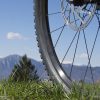
While walking with a sensor is a cheap method, a bicycle with a sensor is faster, more efficient, and better maintains the quality of the data. A team of researchers at the University of Haifa and the Geological Survey of Israel have crafted just such a bicycle.
The first attempt to use a mountain bike utilized the All-Terrain Bicycle Geomagnetic Mapping System (ATBGMS) created in 1998 by a team led by Dr. Chuck Connor at the Southwest Research Institute. The ATBGMS includes a magnetic sensor affixed to a pole extending about 1.3 meters in front of the bike’s handlebars, and the sensor turns along with the handlebars. While more effective than traversing the land on foot, the bike wasn’t durable enough to carry out the surveys.
A New Method for New Terrain
Dr. Uri Schattner of the University of Haifa knew there was a better way. Together with colleagues at the Geological Survey of Israel, Schattner was able to construct a sturdier framework which has been named Bike-Mag. The sensor no longer moves with the handlebars, instead staying fixed in the direction of movement. This allows the bike to be maneuvered easily and allows the bike to be sturdier. Using the Bike-Mag, Dr. Schattner and his team have been able to cover hundreds of miles of rough terrain. By 2022 the bike-mag design had collected ground data along 5,000 km (about 3,100 miles), according to the team’s study in Pure and Applied Geophysics.
Tests were conducted to determine if there were any discrepancies between the two test methods (on foot and the Bike-Mag). The results from both tests were almost identical! However, the spikes in data from the Bike-Mag were smaller than those of the test on foot due to the greater distance between sampling points.
Mapping the rest of Israel is the first task on Dr. Schattner and his team’s list. After that? They plan to combine their data with data already collected to map other regions across the globe.
Keep your eyes on our News & How-Tos blog for more global magnet news updates. Have any compelling questions? Pose them on Facebook and Twitter and we’ll do our best to answer them.
-
Pyrolytic Graphite Magnetic Levitation Kit

- Complete kit to demonstrate diamagnetic levitation.
- Includes (4) 1/2x1/2x1/4 Neodymium block magnets and (1) piece of 1cm x 1cm x 05.mm pyrolytic graphite.
- Pyrolytic graphite is a unique form of graphite produced by decomposition of a hydrocarbon gas, typically methane, at very high temperature in a vacuum furnace, resulting in an ultra-pure product near theoretical density and extremely anisotropic
- SKU# PGMLK
$39.99 -
Magnetic Pole Searcher/Finder
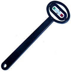
- 1 North/South Pole Magnet Identifier
- The unit consists of a small alnico bar magnet that is gimbal mounted
- SKU# MPS
$10.99 -
12" x 12" Magnetic Field Viewer Film

- 1 Piece Magnetic Field Viewer Film
- The poles appear dark green
- SKU# VF12
$49.99 As low as $42.49